


New article
Recently updated
Running a Point of Closest Approach (PCA) analysis

Who is this article for?Noise analysts who need to measure how close a flight passed to a location.
Access to the ANOMS Noise Analyst Workbench is required.
Point of Closest Approach (PCA) determines the closest distance that occurred between a recorded flight track and a selected ground point on the map, useful for verifying complaints about aircraft passing close to a location.
Understanding PCA analysis
The Map Browser shows a line representing the PCA between the flight track and the map point. PCA analysis requires the PCA and Map Browser windows to be active.
Creating a PCA on the map
To create a PCA analysis:
- Populate the Map Browser with tracks.
- Select the required track from the Map Browser.
- Position the cursor on the map to set the ground reference point.
- Right-click and select PCA to here.
The PCA window appears, showing the flight details, slant distance, height, angle, and range.
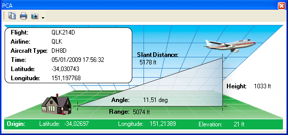
The PCA window showing slant distance, angle, range, and height between the ground point and the flight track
Tip: To set another ground reference point, repeat steps 3 and 4.
Note: The PCA window updates dynamically when you select another flight track or set a new ground position. To run a PCA on a different track, simply select that track in the Map Browser.
Note: A new Origin location can be selected while the PCA window is open, using the Range Settings function on the Map menu. After setting a new Origin, the PCA window updates with the new latitude and longitude.