


New article
Recently updated
Using track filtering to find flights that entered an area

Who is this article for?Noise analysts who need to find flights that entered a specific area of airspace.
Access to the ANOMS Noise Analyst Workbench is required.
Track filtering lets you isolate operations whose radar track passed through a user-defined space drawn on the Map Browser.
Understanding track filtering shapes
You can select from three 3-dimensional shapes: a cylinder, a hemisphere, or an inverted cone. Shapes start from ground level and are centred on the Map Locator. Apply track filtering sequentially and to different regions of the map to determine which operations entered an area of interest, such as a restricted area.
Starting the track filter
To apply track filtering to your operations:
- In the Operations Browser, load operations for the period of interest.
- Select the operations.
- On the main menu, click Map.
- Click Track Filters.
- From the Shape list, select Cylinder, Hemisphere, or Cone.
- In the Radius box, type the required radius.
- In the Height box, type the required height (cylinder filters only).
- For a cone, set the floor and cone angle.
- Click Apply.
Only tracks that passed through the defined space remain selected in the Operations Browser.
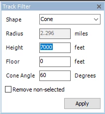
The Track Filter dialogue box with a cone shape selected
Note: The radius unit of measure is determined by the Distance Unit selected in the References function. The height unit of measure is always feet.
Exporting the filtered operations data
Once you have isolated the necessary operations, you can export the data to Excel or copy it to another application.
To export your filtered data:
- Click either the Export button or the Copy button.
Reselecting all operations
To reselect all operations after filtering:
- In the Operations Browser, right-click in the data area.
- Click Select All.