


New article
Recently updated
Showing and hiding map layers with the Feature Manager

Who is this article for?Noise analysts who need to control which layers display on the map.
Access to the ANOMS Noise Analyst Workbench is required. Available layers vary by site configuration.
The Feature Manager window allows you to control map layer visibility, transparency, and display settings for geographical overlays such as highways, airports, and waterways.
Understanding map layers
A map layer is a group of similar map features — such as highways — contained within one graphical overlay. Available layer categories are listed on the tabs of the Feature Manager window, and include Geo, RMTs, Airports, Roads, Gates, and Contours.
Note: Available layers and features vary by site configuration.
Turning map features on and off
To control feature visibility:
- On the Map toolbar, click the Feature Manager button.
- Use the tick boxes to turn features on or off.
- Use the tabs to display the available options.
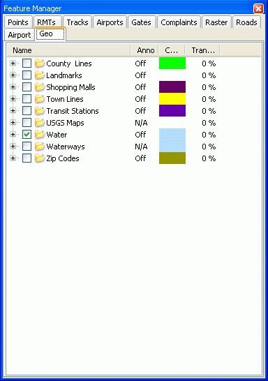
The Feature Manager window on the Geo tab, showing layer tick boxes, annotation status, colour, and transparency
Understanding Feature Manager tabs
Feature tab | Definition |
Geo | Groups the geographical maps — for example Districts, Lakes, Parks, and Waterways. Use the On tick box to display a feature. Use the Auto option, if available, to automatically control the level of detail when zooming. Use the Anno option, if available, to display any system annotations. |
Roads | Groups the roadway maps — for example Major Highways, Tollways, and Streets. Use the On tick box to display a road feature. |
Airports | Groups the airport runway graphics that display the runway orientation and layout. Use the On tick box to display an airport feature. Use the Anno option to display the runway ID. |
RMTs | Groups the RMTs configured in the ANOMS system. Use the tick box to turn each RMT on or off on the Map Browser. Use the RMT Locations Descriptions options to control the level of RMT information displayed. |
Gates | Groups all the gates and corridors set up in the ANOMS system. Use the tick box to turn each gate or corridor on or off on the Map Browser. |
Tracks | Controls how tracks are represented on the Map Browser — for example by altitude or by airline. |
Complaints | Controls the display of complainer details on the Map Browser. The options are Show Address, Show Complainers, and Hide Complainer Details. |
Raster | Contains the raster maps, such as aerial or satellite maps. These maps contain a lot of detail and may be tiled so you can show part or whole maps. |
Points | Controls map references — the locator, grid lines, distance units — and lets you add Points of Interest. |
Setting the transparency of a map feature
To adjust feature transparency and colour:
- Select the Geo or Roads tab to choose which feature to modify.
- Double-click the feature you want to modify.
- Use the slider, or enter a value, in the Transparency section.
- To change the colour of the feature, click the Color button.
- If the feature can also display annotations (such as street names), select the Show Annotations checkbox to display them.
The displayed feature immediately updates to show the new transparency level.