


New article
Recently updated
Controlling the map view with the mouse and keyboard

Who is this article for?Noise analysts who need to zoom, pan and rotate the map in 2D and 3D.
Access to the ANOMS Noise Analyst Workbench is required.
You can zoom, pan, and rotate the map view using the mouse and keyboard together, in either 2D or 3D viewing mode.
Using mouse and keyboard commands
Note: If you do not have a mouse wheel, use the Transform View window instead (see "Using Transform View to set an exact map position").
The following table shows the available mouse and keyboard commands for controlling the map view:
Function | 2D procedure | 3D procedure |
Zoom in | Scroll the mouse wheel forwards | Same as 2D |
Zoom in to a specific section (by drawing a window) | Hold Alt and press the left mouse button with the pointer at the upper-left corner of the area, drag to the lower-right corner, then release | Not available |
Zoom out | Scroll the mouse wheel backwards | Same as 2D |
Zoom out after drawing a window (return to previous zoom) | Hold Alt and click the left mouse button | Not available |
Pan | Click the mouse wheel and drag the mouse in any direction | Same as 2D |
Rotate | Not available | Click and hold the right mouse button. Drag the mouse up or down to change the elevation angle; drag left or right to change the heading |
Return to default view | Press r on the keyboard | Press r on the keyboard |
Cycle windows | Press Ctrl+Tab to tab through open ANOMS windows and dialogue boxes | Same as 2D |
Switching between 2D and 3D views
To switch between viewing modes:
- On the Map toolbar, click 2D/3D.
Depending on which viewing mode you are in, a different map legend is displayed.
Understanding the 2D view Scale Legend
The Scale Legend, shown in 2D view mode, shows the map scale and North arrow. The map scale shows a distance and its scaled distance value as the map is currently displayed (for example, 5,000 metres = 10 centimetres, or 10,000 feet = 1 inch).
Understanding the 3D view Orientation Legend
The Orientation Legend, shown in 3D view mode, shows the Heading and Elevation values. Heading is the compass direction you are looking towards to see the map (0 degrees = North). Elevation is the angle above the horizon that you are viewing the map from.
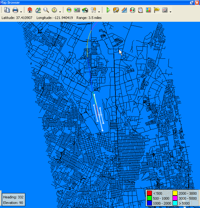
The Map Browser in 3D view, with the Orientation Legend (bottom left) and the altitude colour legend (bottom right)
Using the track legend
The Map Browser also has a user-configured track legend. Click the white bar at its edge to turn the legend on and off. To control what the legend displays, use the Tracks tab in the Feature Manager (see "Showing and hiding map layers with the Feature Manager").